The purpose of this course will be to introduce students to the Global Positioning System (GPS) and to the process of using a GPS device. Students will begin by learning how GPS works with a ‘mini lesson’ on the concept. Afterwards, students will learn how to use a GPS hand-held device or the GPS smartphone app Gaia, depending on the technology available to them. Finally, students will have a chance to practice their navigational skills by completing a scavenger hunt activity while using GPS to help them accomplish their tasks!
Students will then learn to use the ArcGIS Online StoryMaps Program. This will allow students to combine Traditional Ecological Knowledge from Community Elders or Knowledge Keepers and then demonstrate their knowledge by creating a StoryMap of their experiences and learning. Students will begin by collecting relevant information and locations in the field, along with recording complementary images and videos of the knowledge being shared.
Course Objectives
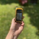
- Students will be able to effectively navigate using a Garmin Etrex 10 GPS Device and/or the GPS Smartphone App, Gaia GPS Mobile Trails Maps.
- Students will be able to demonstrate their understanding using the ArcGIS StoryMaps program.
Time
Approximately 75 minutes.
- GPS Device: Students will need access to a smartphone or a Garmin Etrex 10 GPS Handheld Device
- ESRI Account: Teachers should ensure prior to beginning this lesson that their school board or organization has an ArcGIS for Schools account in order to make use of the StoryMap program. To request a free school account, check here.
- Community Partner(s): Teachers will also need to connect with one or more community members, who have Traditional Ecological Knowledge; who would be willing to share that knowledge with students.
- Digital Camera: Students will need access to a digital camera and/or video recorder to be used in the information collection portion of this lesson.
- Computer with Internet: Students will need access to a computer with internet, in order to use the ERSI program featured in this lesson.
- GPS Device (Optional): Students will need access to a smartphone or GPS Device should they wish to record exact locations of places featured in their StoryMap.
