In 2010, Labrador endured what became known as the “Year of No Winter.” Temperatures were between eight and ten degrees warmer than usual. Three hundred millimetres of rain fell in February. The sea ice—the winter highway used for centuries by Inuit for hunting and travelling— formed imperfectly, when it finally formed at all. It’s estimated that one in twelve people fell through the ice on their snowmobiles.
Things had been increasingly strange for years. Every winter, it seemed, the sea ice formed a little later and thawed a little earlier. Some winters were almost normal, but this had become the exception. Violent storms were more frequent. Some years had too little snow; others, too much. In Labrador, climate change was experienced rather than debated. “I used to be able to clean two fish in the ocean before having to warm my hands,” said one local in Nain. “Now I can clean four.”
The unpredictability was the worst element. Regular sea ice routes that had always been safe in the past could no longer be trusted. Neither could people rely on technology from further south to lend a hand. The Canadian Ice Service, for example, does not produce ice charts in winter, because its role is to help ships, not snowmobilers. Scientists have tended to focus on the big picture, not the local experience—not the number of fish you can clean.
“No one gets promoted at university for measuring sea-ice thickness off an Arctic community,” says Trevor Bell. The Memorial University geographer admits that, at first, he had a somewhat clinical approach to Labrador. “I was your typical scientist,” he says, “flying in and out of communities.”
Originally from Ireland, Bell chose to do his postgraduate work in northern Labrador, studying the more than 100 remnant glaciers that still cling to shadowed cirques in the Torngat Mountains. With money for Arctic research proving scarce, Bell worked in Newfoundland for more than a decade, studying how changing landscapes affect communities and human movement. When climate change and the problem of unpredictable sea ice brought the funding back to Labrador, Bell “returned as a different geographer, more community focused.”
Bell developed two elements of technology to study the now-erratic sea ice. The first was a stationary ice sensor—essentially a long cylinder with protruding, temperature-sensitive nubs called “thermistors,” which is inserted into the ice like a giant thermometer. The lower third of the cylinder records the temperature of the water; the middle third that of the ice; and the top third protrudes like a periscope, registering the temperature of the snow and air. Once a day, a battery-powered SmartBuoy sends a signal of these various temperatures to a satellite. This data is converted into graphs displaying sea-ice thickness— an easy conversion, because of the considerable difference in temperature between water, ice and air—and beamed to a website that is accessible to anyone.
The second device, a kind of ground-penetrating radar, sends out electromagnetic signals that register the difference in electrical conductivity between sea water and sea ice. (It doesn’t work on lake ice, since in that case ice and water have the same conductivity.) Placed on a kamutik—a wooden sled— behind a snowmobile, Bell reasoned, the apparatus would provide a mobile, real-time reading of sea-ice depth as the snowmobile moves around—a SmartKamutik, as it came to be called.
Get SMART
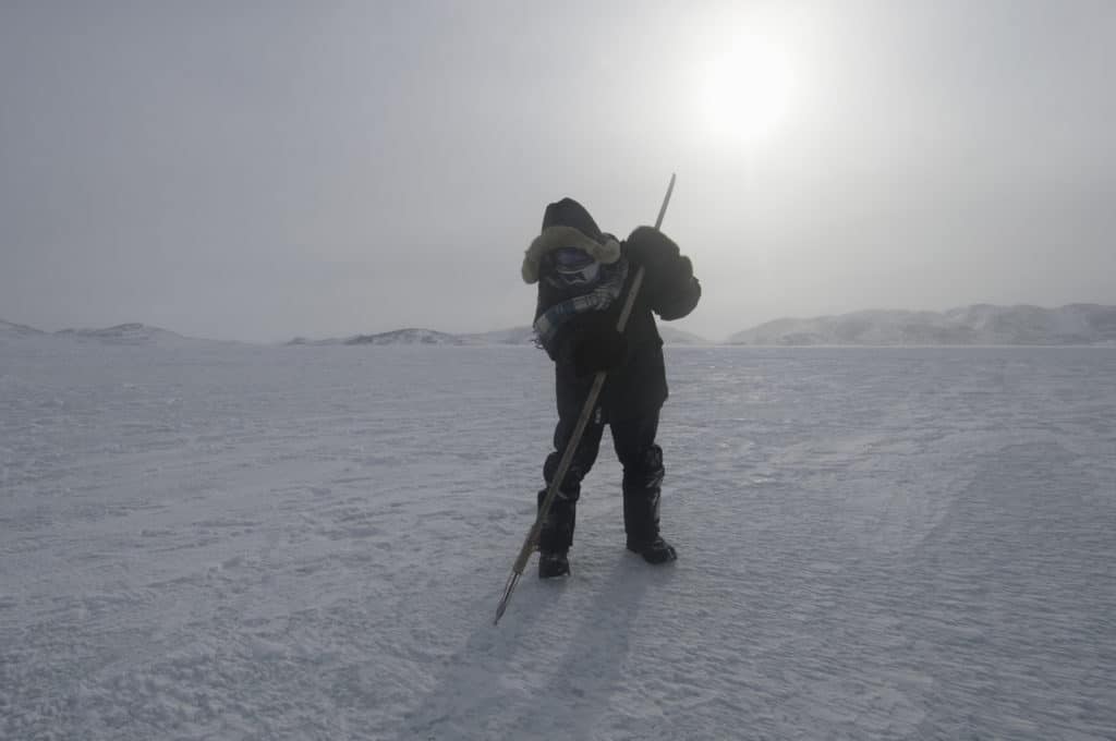
Inuit, of course, have always had their own ways of testing the safety of sea ice. “If you can give three smacks with a harpoon without breaking through, the ice is safe to walk on,” says Derrick Pottle of Rigolet, Labrador. “Five smacks, it’s safe for snowmobiles.” Experienced hunters like Pottle can even tell from the sound the harpoon makes if the ice is good.
Bell’s idea was not to replace such time-honoured knowledge, but rather to add tools to the modern sea-ice traveller’s kit. Young people may spend less time on the land than previous generations, but they can navigate flawlessly around an iPad, so an online portal can shorten their path to knowledge. The technology could even serve elders like Pottle, who has lost four snowmobiles through the ice over the years .
This thinking was the beginning of SmartICE—Sea-Ice Monitoring And RealTime Information for Coastal Environments. After successfully testing prototypes in Nain, Labrador, and Pond Inlet, Nunavut, SmartICE received both encouragement and funding when it was a co-winner of the 2016 Arctic Inspiration Prize [full disclosure: Pinnguaq was the other winner that year. — eds.]. A year later, it won the United Nations Momentum for Change Award, and last year, the Governor General’s Innovation Award.
SmartICE currently employs 13 people, including grassroots workers in each community serviced by the technology, who drive the SmartKamutiks and set up (and remove at the end of each season) the stationary SmartBuoy sensors in potentially unstable areas.
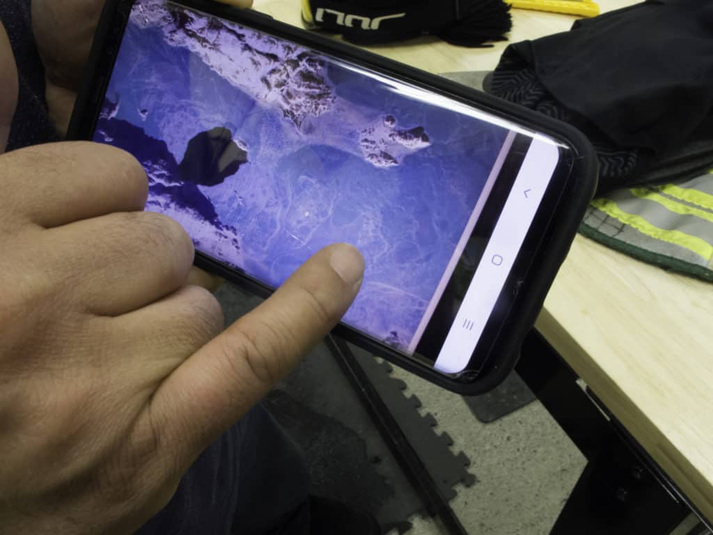
In 2020, SmartICE went online. Now, after each SmartKamutik run or daily SmartBuoy measurement, the sea-ice readings appear automatically on SmartICE’s partner site, siku.org [see page 9 for more on SIKU—eds.], for each of the communities involved.
Although still in its early stages, the SIKU site is rich and rewards exploration. For example, the default view on the righthand panel is a topographical map of the region selected. But clicking the drop-down menu gives a choice of satellites, each of which imparts its own view. Particularly useful are Sentinel 1, an infrared view that shows rougher ice as grey and smooth ice as black; and Sentinel 2, which, on clear days, gives crystal-clear photos of the sea ice from orbit, showing the precise location of patches of open water and obviously weak ice. For those who may be less well-versed in digital navigation, colour printouts of these views will be posted in community centres such as post offices and grocery stores.
While freshwater ice starts off as a thin pane of glass that thickens gradually, sea ice freezes in a more complicated way because of its salt content. Needle-like frazil ice crystals form when the water temperature reaches -1.5°C. These cluster into a greasy grey film, which eventually thickens into nilas—a rubbery membrane that is totally unlike freshwater ice. Even when it’s safe to walk on, nilas flexes spookily beneath you like a waterbed. As a ski glides forward, sometimes ripples even pass through the flexible ice.
Eventually, this rubber ice thickens and becomes white and rigid. For the first several months, sea ice retains its salt content, so it is not drinkable. On early-season journeys, some prehistoric Inuit carried chunks of iceberg ice on their kamutiks for drinking water. But by late winter, enough salt has leached out that sea ice is potable.
Even where there is smooth, landfast ice, a tidal zone of rough ice guards the shore. The width of this band of ice blocks depends on the magnitude of the tide and the depth of the water at the shoreline. Small tides around cliffs may produce an almost negligible tidal zone. But in shallow areas where there are high tides, such as near Iqaluit in Nunavut or Kangiqsualujuaq in Nunavik, the tidal barrier is vast, chaotic and as difficult to pick through as a large field of overturned furniture.
Near the floe edge—where firm sea ice meets open water—ice can break off as a result of currents or storms, and this is always a hazard for hunters. Many have perished when the ice they were on broke free and drifted out into the open water of Baffin Bay. On the island on which Igloolik is located, it is said that if the parkas of all the men who have been lost on the ice were laid side by side, they would reach from Igloolik to the mainland.
As spring advances, melt pools form on the ice, although secure ice rests beneath the shin-deep water. This melting occurs from April in southerly regions like Labrador through early June in the High Arctic. Meanwhile, thinner ice near shallow shores melts, forming a lead of open water that is difficult for travellers to bridge to the secure ice that lies beyond.
Eventually, the melt pools drain through seal holes, leads and cracks in the surface of the ice. Snowless due to warmer temperatures that have yet to affect the sea ice, this frozen surface makes for excellent travel for a time. However, the pools thin the connections between the drier areas of ice. Eventually, they break apart to become free-floating ice floes, which may still be up to a metre thick—solid enough to stand on, but with only open ocean between them.
As summer progresses, the floes drift, shrinking, breaking up into smaller pieces and sometimes melting altogether. In this warmer era, first-year ice usually disappears entirely. But in the past or during a rare cold summer, some floes remain when the fall freeze-up sets in. This evolves into multi-year ice, whose sharp peaks have melted into rounded knolls. Multi-year ice used to be prominent in the High Arctic and the Arctic Ocean, but it has now largely disappeared.
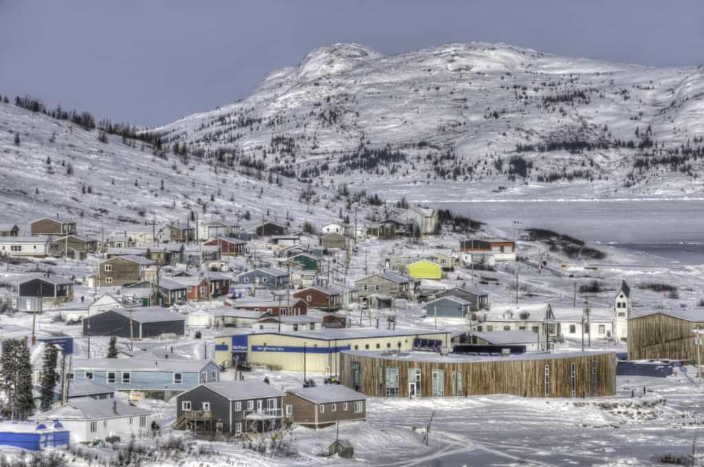
North to Nain
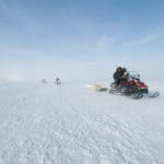
With its distinctive angry-bee sound, the Twin Otter reverses its props as it touches down on Nain’s dirt airstrip. I have come to witness the deployment of northern Labrador’s first SmartBuoy. My visit was supposed to have taken place much earlier, but it has been another of those winters that are becoming all too familiar. While it has been cold enough—perhaps because of the warmer, four-fish water, perhaps due to something else—the sea ice has been slow to form. Even at the end of January, it had not been safe. This was the latest anyone could remember it freezing. Now, in late February, the open ocean looms disturbingly close, especially near Nain and Natuashish. On the flight in, patches of open water, known as “rattles” in Labrador, stood out like eyes on the white ice.
Ice, and the lack of it, are not the only topics of conversation along the coast. More than one person comments that there has been so little snow, they haven’t needed snowshoes to go “wooding”—gathering firewood. The snow is barely ankle deep. Meanwhile, the winter before, so much early snow had fallen that it hindered ice formation. Every year, it seems, something is screwy.
After settling in, I go to the SmartICE office and meet Rex Holwell, the northern operations head. After 14 years working for the Voisey’s Bay mine, Holwell, 45, wanted a new challenge. Not only does he manage SmartICE in Nain—the practical centre of the project, with St. John’s as its administrative headquarters—but he also travels around the Arctic, training operators and introducing the technology to other communities. In a few days, he is flying to Kinngait, Nunavut. So many towns want to adopt the technology that there is a waiting list.
The main part of the SmartICE office is a simple workshop where the SmartKamutik components are stored and the SmartBuoys are assembled. The walls are adorned with a mixture of tools and encouraging homilies. Trevor Bell had not wanted the technology he developed simply exported here from Mississauga or Shenzhen. Instead, four young people in Nain were trained for six weeks on how to put the buoys together. The latest group assembled seven: one for Nain, the rest bound for other partnering communities. (To keep up with the demand, some are now assembled in St. John’s.)
Holwell also teaches the trainees, aged 18 to 30, first aid and soft skills such as writing résumés and cover letters for job applications.
While this community involvement is not directly related to making sea ice safer for travel, it is a vital part of the broader SmartICE mission. Of the youth who went through Holwell’s first edition of the training program in 2019, two moved on to study at a college in Goose Bay. Another works fulltime at Voisey’s Bay.
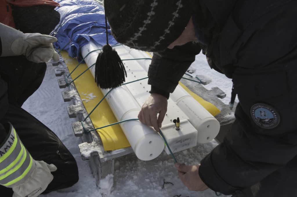
The SmartBuoy we are to deploy was assembled here in Nain by SmartICE trainees. It lies on the long workshop table, about three metres long and weighing almost 70 kilograms. It consists of two long plastic cylinders joined in the centre. At one end, encased in the watertight plastic compartment, 16 D-cell batteries power the unit. Small metal studs, 60 in all, erupt from the plastic cylinder every two centimetres. These are the thermistors, hooked up to a motherboard contained in the housing. Each SmartBuoy costs in the range of $20,000, most of that for the custommolded plastic tubes. The SmartKamutik instrument costs significantly more.
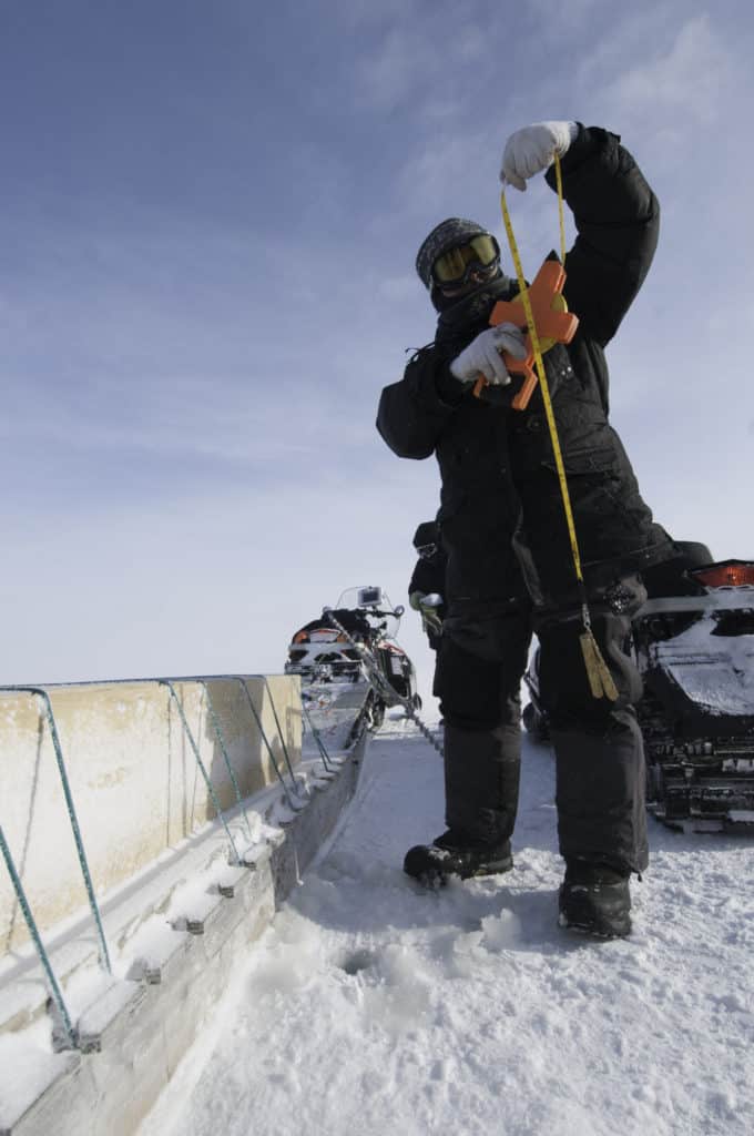
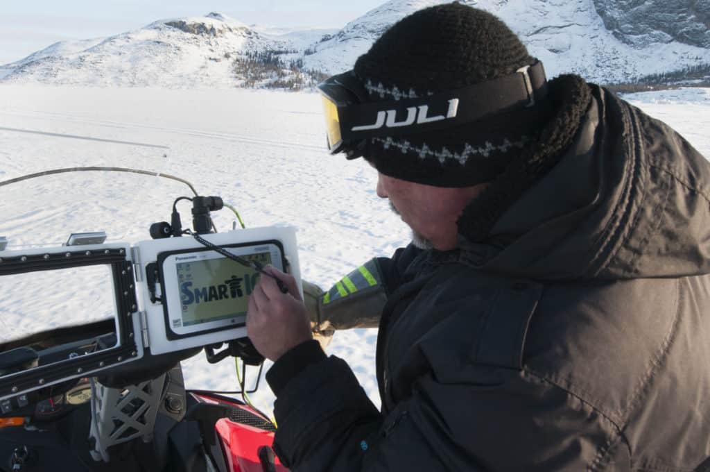
On the floor, in a long wooden box, lies a device Bell likens to bat sonar. Consisting of two long tubes, fused in the centre by a metal box, it is lashed to a kamutik behind a snowmobile, and gives real-time readings of the thickness of the ice it travels over. It has no batteries, as it is powered by the snowmobile. A small, tablet-sized LCD screen attaches to the handlebars of the snowmobile and displays graphic readings of ice thickness, similar to what will later appear on the SIKU site. The SmartKamutik instrument costs just a little more than a SmartBuoy. By the end of this winter, 19 Arctic communities will have one.
In the evening, Holwell briefs the Nain Town Council on SmartICE. Reasonably, they want to know who is paying for it all? The town? The Nunatsiavut Government? Newfoundland and Labrador? The feds? It seems to be a mix of all arms of government. Part of SmartICE’s mandate is to find sources of funding to make the project sustainable.
Holwell announces that, as of this week, everyone is able to check out the SmartICE ice data for themselves on SIKU. They also discuss at length where to moor the buoy. For the future, the idea is to plant several—the Council is interested in four more, to begin with—in well-trafficked areas where the ice has been problematic in recent years. However, it would be best not to place them in unstable ice that might break up without warning. Although the buoys float and GPS indicates their position for retrieval, grinding ice might still damage them, despite their formidable, waterproof plastic housing.
In the end, they decide to moor their buoy about 40 kilometres east of Nain, near some small rattles. Many hunters come to this area, because seals like these small, nutrient-rich areas of open water. And everyone likes seal—boiled, fried and raw.
Upon hearing Holwell’s presentation, I wonder about the usefulness of the buoys versus the kamutiks. The SmartKamutiks can go anywhere, including those places where the buoys are moored. They provide readings of ice thickness over dozens of kilometres at a run. Meanwhile, the buoy sits in one spot, in solid ice. It is mainly in mid-spring that it might indicate thinning to the point of danger. For the cost of the four extra SmartBuoys Nain was considering, they could pay a couple of young trainees to drive a SmartKamutik on all the regular routes several times a week. From the perspectives of economics and safety, the SmartKamutiks seem to offer more value, even at the higher price.
However, a stationary sensor in the same place every year, gathering daily data over a period of several months, will indicate whether the ice is thinning overall, and so has both scientific and safety applications. And as the SmartBuoys are built in Nain, while the SmartKamutik technology is not, the buoys serve SmartICE’s social enterprise efforts.
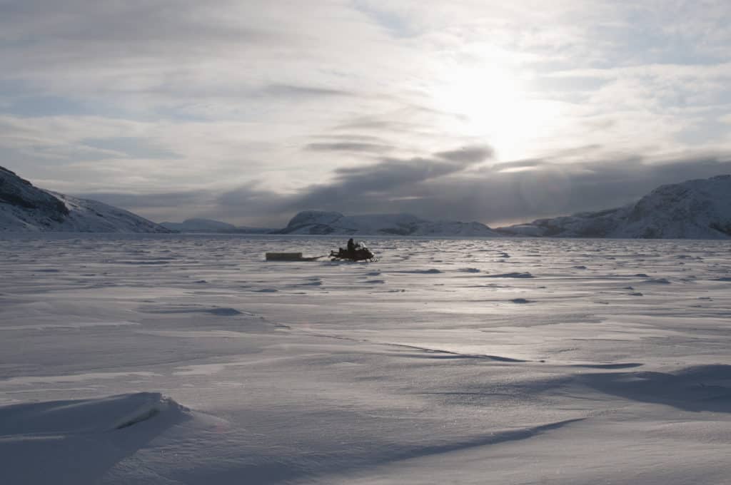
By the end of February, the winter sun has gained strength, and an air temperature of -17°C does not feel particularly cold. But on the morning Holwell is to deploy Nain’s first home-built SmartBuoy, 70 kilometre-an-hour west winds are ripping over the ice. The ride out, with the wind at our backs, will be OK, but standing around, and especially driving back into the teeth of the wind, will require serious layers.
Joining Holwell for the deployment are three trainees. David Kohlmeister, 30, enjoyed his experience with the initial SmartBuoy program so much that he has come back on the second as a mentor, while Ama Harris, 22, and Suzie Kohlmeister, 21, who helped to assemble this particular buoy, are driving support snowmobiles.
The wind funnels through the islands off the shore from Nain, and little snow covers the flat, nubbly sea ice. This makes for fast going, but the lack of a snow-padded surface is hard on the snowmobiles.
When we first touch sea ice, Holwell fires up the SmartKamutik’s sensors. Later, we stop a second time and drill a small hole in the ice to make sure the sensors have been properly calibrated. The radar reading of the ice’s thickness comes within two centimetres of a manual tape measure: all is well.
After about an hour, we reach the designated site. The open water, less than a kilometre away, is invisible because of the ground blizzard. Holwell drills two holes, side by side, with a battery-powered auger. Then Kohlmeister chisels away the ice between them. Together, they insert the SmartBuoy in the hole. It sinks, bobbing a little at first, and eventually leaves a little less than a metre of the tube protruding above the ice. Holwell wedges it firmly in place with foam blocks. Done. Across the Arctic this spring, 22 new SmartBuoys will undergo similar initiation.
Farther south, Canadians often think of cold as something to avoid or to endure. But in the north, the ice season is everyone’s favourite time of year. It’s when travelling and hunting are easiest. “White men think of ice as frozen water, but Inuit think of water as melted ice,” the great Inuit explorer Nukapinguaq once said. “To us, ice is the natural state.”
Even today, of the 51 communities in the four Canadian Inuit regions, 48 are on the coast. “That tells the value of sea ice to us,” says Derrick Pottle.
But whether that surface will persist is in serious doubt, especially in more southerly regions like Labrador. With the climate crisis, the greatest danger is not a slow, linear decline in the thickness of sea ice, or an incrementally shorter season every decade. It’s what scientists call a tipping point: when climate change crosses an invisible line and precipitates a sudden cascade of events—an unforeseen shift in ocean currents, for example.
Even without telltale numbers, the tipping point is a palpable threat to the traditional Inuit way of life. When a four-fish sea water temperature becomes six- or eight-fish temperature, the sea might be simply too mild to create ice that is safe for travel. Or it might freeze for only a couple of weeks each winter, making a $20,000 snowmobile a poor investment. Parts of the Canadian Arctic might soon go the way of areas of western Greenland, where year-round fishing has replaced sea-ice culture.
In the meantime, these new tools to monitor sea ice, together with traditional knowledge, will extend this way of life as long and as safely as possible. “SmartICE will definitely help,” says Pottle, “but I need to be smart out there, too.”
Although people have lived in Labrador for at least 8,000 years, almost since the retreat of the last ice sheet, Nain is both the northernmost settlement on the Labrador coast and the oldest still in existence. The Moravian Brethren, a sect of German missionaries, founded Nain in 1771, largely thanks to the diplomatic help of an Inuit woman named Mikak.
At first, the Inuit did not take kindly to European interlopers. In 1606, John Knight was slain when he landed near the site of Nain to repair his ship. And in 1752, when the Moravians first tried to establish a settlement named Hoffenthal near present-day Makkovik, they were killed by Inuit.
A Moravian named Jens Haven, who had already conducted missionary work in Greenland, believed the Brethren’s cause still had potential in Labrador, and enlisted Mikak to aid in smoothing the way. A gifted woman, Mikak first met Haven in 1765. She was interested in the culture of the newcomers, learned English, and it seems she was not even disillusioned when she was kidnapped and taken to England as a curiosity, as were so many Inuit in that early settlement era. She forged royal friendships, had her portrait painted, and, later, when she returned to Labrador, advocated on behalf of the Moravians.
Named after the biblical village in Galilee, Nain was the first of several missions along the Labrador coast. Those Inuit who disliked the subtle (and not-so-subtle) pressures within these missionary settlements moved north to the Torngat Mountains to live as nomads and follow their own spiritual traditions.
Well into the 20th century, there were Moravian communities farther north than Nain. Then, in 1918, the ill-named supply ship Harmony introduced the Spanish flu, which decimated the towns of Okak and Hebron. Okak was shut down; Hebron survived until 1957, when, in an attempt to centralize access to institutional services, the colonial government shuttered it and forced its residents to resettle in towns to the south.
When the Inuit regional government of Nunatsiavut was established in 2005, Nain became its administrative capital. Still 600 kilometres north of the nearest road, the town is serviced by small planes, as well as a coastal ferry in summer and seasonal snowmobile routes in winter. Although Nain is only as far north as Edinburgh, the cold North Atlantic current makes Labrador the most frigid place in the world at its latitude. While trees linger around Nain, the Arctic tundra is not far away.
This article originally appeared in the first issue of Root & STEM, Pinnguaq’s free print and online STEAM resource supporting educators in teaching digital skills

